1/15
Mapit GIS - Map Data Collector & Land Surveys screenshot 0
Mapit GIS - Map Data Collector & Land Surveys screenshot 1
Mapit GIS - Map Data Collector & Land Surveys screenshot 2
Mapit GIS - Map Data Collector & Land Surveys screenshot 3
Mapit GIS - Map Data Collector & Land Surveys screenshot 4
Mapit GIS - Map Data Collector & Land Surveys screenshot 5
Mapit GIS - Map Data Collector & Land Surveys screenshot 6
Mapit GIS - Map Data Collector & Land Surveys screenshot 7
Mapit GIS - Map Data Collector & Land Surveys screenshot 8
Mapit GIS - Map Data Collector & Land Surveys screenshot 9
Mapit GIS - Map Data Collector & Land Surveys screenshot 10
Mapit GIS - Map Data Collector & Land Surveys screenshot 11
Mapit GIS - Map Data Collector & Land Surveys screenshot 12
Mapit GIS - Map Data Collector & Land Surveys screenshot 13
Mapit GIS - Map Data Collector & Land Surveys screenshot 14
Mapit GIS - Map Data Collector & Land Surveys Icon

Mapit GIS - Map Data Collector & Land Surveys

Andrzej Bieniek
Trustable Ranking Iconविश्वसनीय
2K+डाउनलोड
13.5MBआकार
Android Version Icon4.1.x+
एंड्रॉइड संस्करण
7.8.0.0Core(16-08-2021)नवीनतम संस्करण
4.5
(4 रिव्यू)
Age ratingPEGI-3
विवरणरिव्यूसंस्करणजानकारी
1/15

का विवरण Mapit GIS - Map Data Collector & Land Surveys

Mapit is a professional, stand-alone, cost effective mapping and surveying tool designed to enhance productivity while you are out there in the field.


The app supports common file formats for input and output and is capable to work with number of external GNSS receivers so you can get a centimetre level accuracy when you need to.


Design your survey forms, organize data on layers, work offline with mbtiles base-maps, access WMS services, use GPS tracking to capture your line and polygon features, record GNSS metadata and much more to discover.


The app is widely used by professionals around the world and can be easily adopted for different applications from agriculture and forestry to road construction, geology, land surveying and solar panel solutions. Personalized settings and flexibility makes this app fit for purpose tool which will enhance your surveying workflow.


App can be also used as a measurement tool to calculate areas or distances.


When saving location simply choose required attributes from predefined drop-down list, no need to type the same information over and over again. Import long list of attributes from text files and re-use them in number of projects. If necessary you can add pictures to each location as well.


If you are working in the field, gathering large amount of spatial data this app is designed for you.


Speed up your workflow and make the data collection more efficient. Take advantage of survey layers and possibility to re-use same set of attributes for multiple surveys. Export your data to common GIS formats like Esri shapefiles, CSV, KML, geojson, DXF, GPX and post process your data using Desktop GIS software like qGIS.

Support for number of predefined coordinate systems and customised EPSG codes if required.

Mobile Data Collection Features:


- Base maps: Popular online maps selections and offline mbtiles,

- Support for RTK corrected coordinates when external Bluetooth GPS / GNSS is connected,

- Support for WMS and GIS Server Tiled map services - load topographic and orthophoto maps, geological surveys, cadastral information and number of other services.

- Possibility to create and maintain sets of attributes - these are available as a drop down lists when new feature is being recorded, long lists of values can be imported from text files.

- Clusters for point map markers, efficient way of having large number of points on the map without performance issues,

- Currently 4 methods of collection are supported (GPS / GNSS location, map cursor location, tracking, point projection using angle and distance),

- Possibility to group your data into the survey layers - each survey layer may have a default set of attributes.

- Local SD card or remote export. At the moment shapefiles, KML, CSV, geojson, GPX and DXF export is supported,

- Direct export to Dropbox or FTP location

- Possibility to record multiple points, lines and polygons on one layer,

- When creating new polygon or line features measurement details like area or length are also available.

- GPS / GNSS and satellites status,

- Address, location search,

- Import point, line and polygon features into layer from CSV, KML, shapefile or geojson file,

- Backup management,

- Import/Export attributes from file and much more to discover...


Our users are successfully using Mapit in number of applications including:

- Environmental and woodland surveys,

- Forestry planning and woodland management,

- Agriculture and soil classifications and sampling,

- Road constructions,

- Land surveying,

- Solar panels applications,

- Roofing and fencing,

- Tree surveys,

- GPS and GNSS surveying,

- Site surveying

- Snow removal


Do not hesitate to contact us directly or using the contact form on our website.

मैपिट एक पेशेवर, स्टैंड-अलोन, लागत प्रभावी मैपिंग और सर्वेक्षण उपकरण है जिसे उत्पादकता बढ़ाने के लिए डिज़ाइन किया गया है जब आप क्षेत्र में हैं।


एप्लिकेशन इनपुट और आउटपुट के लिए सामान्य फ़ाइल स्वरूपों का समर्थन करता है और बाहरी GNSS रिसीवरों की संख्या के साथ काम करने में सक्षम है, ताकि आपको आवश्यकता होने पर एक सेंटीमीटर स्तर सटीकता मिल सके।


अपने सर्वेक्षण प्रपत्रों को डिज़ाइन करें, परतों पर डेटा व्यवस्थित करें, mbtiles बेस-मैप्स के साथ ऑफ़लाइन काम करें, WMS सेवाओं तक पहुंचें, अपनी लाइन और बहुभुज सुविधाओं को कैप्चर करने के लिए GPS ट्रैकिंग का उपयोग करें, GNSS मेटाडेटा रिकॉर्ड करें और खोजने के लिए और भी बहुत कुछ।


एप्लिकेशन को दुनिया भर के पेशेवरों द्वारा व्यापक रूप से उपयोग किया जाता है और कृषि और वानिकी से सड़क निर्माण, भूविज्ञान, भूमि सर्वेक्षण और सौर पैनल समाधानों के लिए विभिन्न अनुप्रयोगों के लिए आसानी से अपनाया जा सकता है। निजीकृत सेटिंग्स और लचीलापन इस ऐप को उद्देश्य उपकरण के लिए उपयुक्त बनाता है जो आपके सर्वेक्षण वर्कफ़्लो को बढ़ाएगा।


ऐप का उपयोग क्षेत्रों या दूरियों की गणना करने के लिए एक माप उपकरण के रूप में भी किया जा सकता है।


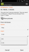
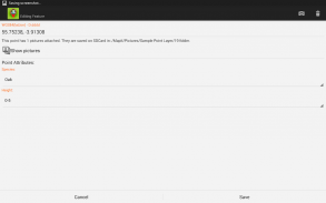
स्थान की बचत करते समय बस पूर्वनिर्धारित ड्रॉप-डाउन सूची से आवश्यक विशेषताओं को चुनें, एक ही जानकारी को बार-बार टाइप करने की आवश्यकता नहीं है। पाठ फ़ाइलों से विशेषताओं की लंबी सूची आयात करें और उन्हें परियोजनाओं की संख्या में फिर से उपयोग करें। यदि आवश्यक हो तो आप प्रत्येक स्थान पर चित्र भी जोड़ सकते हैं।


यदि आप क्षेत्र में काम कर रहे हैं, तो बड़ी संख्या में स्थानिक डेटा एकत्र करके यह ऐप आपके लिए डिज़ाइन किया गया है।


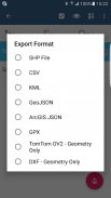
अपने वर्कफ़्लो को गति दें और डेटा संग्रह को अधिक कुशल बनाएं। सर्वेक्षण परतों और एकाधिक सर्वेक्षणों के लिए समान विशेषताओं के पुन: उपयोग की संभावना का लाभ उठाएं। अपने डेटा को सामान्य जीआईएस प्रारूपों जैसे एस्री शेपफाइल्स, सीएसवी, केएमएल, जियोजोन, डीएक्सएफ, जीपीएक्स जैसे निर्यात करें और अपने डेटा को क्यूजीआईएस जैसे डेस्कटॉप जीआईएस सॉफ्टवेयर का उपयोग करके संसाधित करें।

यदि आवश्यक हो तो पूर्वनिर्धारित समन्वय प्रणाली और अनुकूलित EPSG कोड की संख्या के लिए समर्थन।

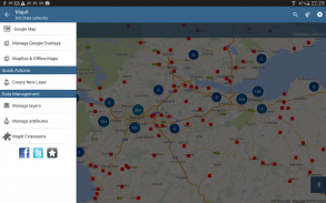
मोबाइल डेटा संग्रह विशेषताएं:


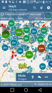
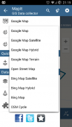
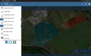
- आधार नक्शे: लोकप्रिय ऑनलाइन मानचित्र चयन और ऑफ़लाइन mbtiles,

- बाहरी ब्लूटूथ GPS / GNSS कनेक्ट होने पर RTK के लिए निर्देशांक का समर्थन सही हो जाता है,

- डब्ल्यूएमएस और जीआईएस सर्वर के लिए समर्थन टाइल की गई मैप सेवाएं - स्थलाकृतिक और आर्थोपोटो नक्शे, भूवैज्ञानिक सर्वेक्षण, कैडस्ट्राल जानकारी और अन्य सेवाओं की संख्या लोड करें।

- विशेषताओं के सेट बनाने और बनाए रखने की संभावना - ये एक ड्रॉप डाउन सूचियों के रूप में उपलब्ध हैं जब नई सुविधा दर्ज की जा रही है, मूल्यों की लंबी सूची को पाठ फ़ाइलों से आयात किया जा सकता है।

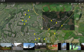
- बिंदु मानचित्र मार्करों के लिए क्लस्टर, प्रदर्शन मुद्दों के बिना मानचित्र पर बड़ी संख्या में अंक होने का कुशल तरीका,

- वर्तमान में संग्रह के 4 तरीके समर्थित हैं (GPS / GNSS स्थान, मानचित्र कर्सर स्थान, ट्रैकिंग, कोण और दूरी का उपयोग करके बिंदु प्रक्षेपण),

- अपने डेटा को सर्वेक्षण परतों में समूहित करने की संभावना - प्रत्येक सर्वेक्षण परत में विशेषताओं का एक डिफ़ॉल्ट सेट हो सकता है।

- स्थानीय एसडी कार्ड या दूरस्थ निर्यात। फिलहाल शेपफाइल्स, केएमएल, सीएसवी, जियोजोन, जीपीएक्स और डीएक्सएफ एक्सपोर्ट समर्थित है,

- ड्रॉपबॉक्स या एफ़टीपी स्थान पर सीधे निर्यात

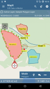
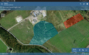
- एक परत पर कई बिंदुओं, रेखाओं और बहुभुजों को रिकॉर्ड करने की संभावना।

- नया बहुभुज या लाइन बनाते समय क्षेत्र या लंबाई जैसे माप विवरण भी उपलब्ध हैं।

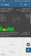
- GPS / GNSS और उपग्रहों की स्थिति,

- पता, स्थान खोज,

- CSV, KML, शेपफाइल या जियोजोन फ़ाइल से परत में आयात बिंदु, रेखा और बहुभुज सुविधाएँ,

- बैकअप प्रबंधन,

- फ़ाइल से आयात / निर्यात विशेषताएँ और बहुत कुछ पता चलता है ...


हमारे उपयोगकर्ता सफलतापूर्वक कई अनुप्रयोगों सहित Mapit का उपयोग कर रहे हैं:

- पर्यावरण और वुडलैंड सर्वेक्षण,

- वानिकी योजना और वुडलैंड प्रबंधन,

- कृषि और मृदा वर्गीकरण और नमूना,

- सड़क निर्माण,

- भूमि सर्वेक्षण,

- सौर पैनल अनुप्रयोग,

- छत और बाड़ लगाना,

- पेड़ सर्वेक्षण,

- जीपीएस और जीएनएसएस सर्वेक्षण,

- साइट सर्वेक्षण

- बर्फ हटाना


हमारी वेबसाइट पर सीधे संपर्क करें या संपर्क फ़ॉर्म का उपयोग करने में संकोच न करें।


Mapit GIS - Map Data Collector & Land Surveys - Version 7.8.0.0Core

(16-08-2021)
अन्य संस्करण
What's newFIX: Some minor bugs removed.CHANGE: When option "share" is chosen during the export, now user is shown possible option every time. ADD: Possibility to exclude attribute when "Last added as default" is selected in Survey Settings. If this option is enabled for the attribute the form field is populated with default value or left blank.ADD: Possibility to set default value for a particular value in dropdown list.

There are no reviews or ratings yet! To leave the first one please

-
4 Reviews
5
4
3
2
1
Info Trust Icon
अच्छी एप्प की गारंटीइस एप्प ने वायरस, मैलवेयर व अन्य दुर्भावनापूर्ण हमलों के लिए सुरक्षा परीक्षण पास किया और इसमें कोई जोखिम नहीं है।

Mapit GIS - Map Data Collector & Land Surveys - एपीके जानकारी

एपीके संस्करण: 7.8.0.0Coreपैकेज: com.osedok.gisdatacollector
एंड्रॉयड संगतता: 4.1.x+ (Jelly Bean)
डेवलपर:Andrzej Bieniekगोपनीयता नीति:https://sites.google.com/view/mapitprivacypolicyअनुमतियाँ:14
नाम: Mapit GIS - Map Data Collector & Land Surveysआकार: 13.5 MBडाउनलोड: 728संस्करण : 7.8.0.0Coreजारी करने की तिथि: 2023-11-07 19:26:44न्यूनतम स्क्रीन: SMALLसमर्थित सीपीयू:
पैकेज आईडी: com.osedok.gisdatacollectorएसएचए1 हस्ताक्षर: 72:72:DE:74:E5:41:17:E4:3E:4B:0E:3E:13:9C:42:58:4A:E2:C4:1Fडेवलपर (CN): Andrzej Bieniekसंस्था (O): स्थानीय (L): Motherwellदेश (C): GBराज्य/शहर (ST):

Latest Version of Mapit GIS - Map Data Collector & Land Surveys

7.8.0.0CoreTrust Icon Versions
16/8/2021
728 डाउनलोड10.5 MB आकार

अन्य संस्करण

7.6.0.0CoreTrust Icon Versions
15/11/2020
728 डाउनलोड10.5 MB आकार
7.5.3CoreTrust Icon Versions
17/9/2020
728 डाउनलोड14.5 MB आकार
7.5.2CoreTrust Icon Versions
16/7/2020
728 डाउनलोड14.5 MB आकार
7.5.1CoreTrust Icon Versions
11/7/2020
728 डाउनलोड14.5 MB आकार
7.5.0CoreTrust Icon Versions
21/6/2020
728 डाउनलोड15.5 MB आकार
7.2.5CoreTrust Icon Versions
19/1/2020
728 डाउनलोड15 MB आकार
7.2.3CoreTrust Icon Versions
1/11/2019
728 डाउनलोड15 MB आकार
7.1.5CoreTrust Icon Versions
6/3/2019
728 डाउनलोड15.5 MB आकार
6.9.2CoreTrust Icon Versions
13/10/2018
728 डाउनलोड12 MB आकार

Apps in the same category

You may also like...